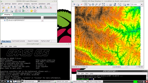
GRASS GIS is a Geographic Information System used for geospatial data management and analysis, image processing, graphics/map production, spatial modeling, and visualization. They now have a Raspberry Pi version.
GRASS GIS is a Geographic Information System used for geospatial data management and analysis, image processing, graphics/map production, spatial modeling, and visualization. They now have a Raspberry Pi version.
[…] recantha GRASS GIS is a Geographic Information System used for geospatial data management and analysis, […]
[…] ที่มา http://grasswiki.osgeo.org/wiki/Raspberry_Pi ผ่านทาง http://178.62.14.192/?p=3759 […]